¶ UAV mapping etc
| Company | Ninox Robotics |
| Country | Australia |
| Website | https://ninox-robotics.com/services/forestry |
| Category | Planning & Inventory › Remote sensing & mapping |
¶ Overview
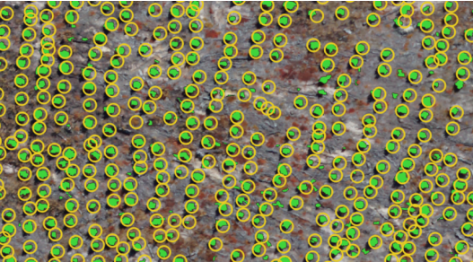
UAV mapping — encompassing photogrammetric orthomosaic production, digital surface and terrain modelling, LiDAR point-cloud capture, and multispectral index mapping — has become a foundational remote sensing technique in modern forestry, offering a flexible and cost-effective bridge between coarse satellite imagery and expensive manned-aircraft surveys. The process begins with mission planning software (such as DJI Pilot 2, Pix4Dcapture, or QGroundControl) that defines flight lines, altitude, overlap percentage, and sensor triggers to ensure complete area coverage at the required ground sample distance (GSD). Imagery or point-cloud data captured in flight are then processed using structure-from-motion (SfM) photogrammetry or LiDAR processing pipelines to produce georeferenced 2-D orthomosaics, 3-D point clouds, digital elevation models, and derived vegetation indices such as NDVI and EVI. In plantation forestry, UAV mapping supports stand inventory by enabling automated tree counting, crown area measurement, height estimation, and early identification of mortality or growth anomalies. In native forest management, it assists in habitat mapping, threatened species surveys, weed encroachment detection, and post-disturbance assessment following fire, flood, or storm events. Fixed-wing UAVs — such as the senseFly eBee X or Wingtra One — offer extended range and coverage ideal for large estate mapping, while multirotor platforms provide flexibility for complex terrain and detailed site investigations. In Australia, UAV mapping is widely adopted by state forest agencies (including Forestry Corporation NSW, VicForests, and Forestry and Land Scotland equivalents such as OneFortyOne Plantations), carbon project developers, and ecological consultancies. The Civil Aviation Safety Authority (CASA) regulates UAV mapping operations, with many commercial operators holding Remote Pilot Licences (RePL) and operating under ReOC authorisations. Integration with GIS platforms such as ESRI ArcGIS, QGIS, and cloud services like Esri ArcGIS Online and Trimble Forestry enables seamless delivery of mapping products into operational forest management workflows.
¶ Assessment
A practical system for improving management efficiency with detailed stand data, though its risk-reduction evidence is moderate and not strongly quantified.
¶ Details
| Field | Value |
|---|---|
| Company | Ninox Robotics |
| Country | Australia |
| Type | Company |
| FWPA RD&E | 7.3 |